Trail Walking Saint-Cyr-de-Salerne - les 4 clochers 2 - Photo
 malikd
malikd

User

© OpenStreetMap contributors
Length
Length
9.5 km
Max alt
Max alt
162 m
Uphill gradient
Uphill gradient
88 m
Km-Effort
Km-Effort  
10.7 km
Min alt
Min alt
118 m
Downhill gradient
Downhill gradient
89 m
Boucle
Boucle
Yes
Creation date :
2019-04-02 17:30:23.54
Updated on :
2019-04-02 17:30:23.645

(1 Reviews)

Walking
Walking
3h39
Difficulty : Easy

Scan this QR Code to open this trail in the SityTrail application

FREE GPS app for hiking

Logo SityTrail SityTrail

IGN / Geographical institutes

Download SityTrail from the App Store Download SityTrail from Google Play

Logo SityTrail SityTrail World

The world is yours!

Download SityTrail from the App Store Download SityTrail from Google Play Download SityTrail on Huawei AppGallery

About

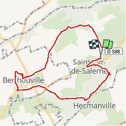
Trail Walking of 9.5 km to be discovered at Normandy, Eure, Saint-Cyr-de-Salerne. This trail is proposed by malikd.

Description

beaucoup a decouvert.

Elevation profile

Points of interest

Point of interest Saint-Cyr-de-Salerne - repas - Photo
malikd
SAINT-CYR-DE-SALERNE 
Point of interest Saint-Cyr-de-Salerne - petite pause - Photo
malikd
SAINT-CYR-DE-SALERNE 
Point of interest Saint-Cyr-de-Salerne - pause gouter - Photo
malikd
SAINT-CYR-DE-SALERNE 

Positioning

Country:
France
Region :
Normandy
Department/Province :
Eure
Municipality :
Saint-Cyr-de-Salerne
Location:
Unknown
Start:(UTM)
329577 ; 5450637 (31U) N.

Comments

Please log in to post a review or rate the element


Cool


Trails nearby

Trail Walking Brionne - Circuit du Donjon - Brionne  - Photo
Walking
tracegps

Walking

Very difficult
(1)
Brionne, Normandy, Eure, France
21 km | 25 km-effort
5h 19min
Yes
Trail Walking Livet-sur-Authou - 20220815 - Photo
Walking
Vivie21

Walking

Easy
Livet-sur-Authou, Normandy, Eure, France
9.4 km | 10.9 km-effort
1h 43min
No
Trail Walking Brionne - Marche Brionne - Photo
Walking
bganiv01

Walking

(1)
Brionne, Normandy, Eure, France
7.3 km | 8.8 km-effort
1h 18min
Yes
Trail Equestrian Saint-Victor-d'Épine - Morsan Saint-victor - Photo
Equestrian
carriedanny

Equestrian

Easy
(1)
Saint-Victor-d'Épine, Normandy, Eure, France
16.8 km | 18.4 km-effort
Unknown
Yes
Trail Walking Nassandres sur Risle - Circuit des Etangs - Fontaine la Soret - Photo
Walking
tracegps

Walking

Medium
(1)
Nassandres sur Risle, Normandy, Eure, France
8.2 km | 9.7 km-effort
2h 4min
Yes
Trail Equestrian Brionne - Circuit du Donjon - Brionne  - Photo
Equestrian
tracegps

Equestrian

Difficult
Brionne, Normandy, Eure, France
21 km | 25 km-effort
4h 0min
Yes
Trail Mountain bike Brionne - Circuit du Donjon - Brionne  - Photo
Mountain bike
tracegps

Mountain bike

Difficult
Brionne, Normandy, Eure, France
21 km | 25 km-effort
2h 0min
Yes
Trail Equestrian Brionne - Circuit forestier - Brionne - Photo
Equestrian
tracegps

Equestrian

Difficult
Brionne, Normandy, Eure, France
14.2 km | 17.2 km-effort
3h 0min
Yes
Trail Mountain bike Brionne - Circuit forestier - Brionne - Photo
Mountain bike
tracegps

Mountain bike

Medium
Brionne, Normandy, Eure, France
14.2 km | 17.2 km-effort
1h 19min
Yes


Close
My subscriptions