Trail Walking Belfort - Rando-les hauts de belfort - Photo
© OpenStreetMap contributors
Length
Length
9.4 km
Max alt
Max alt
450 m
Uphill gradient
Uphill gradient
169 m
Km-Effort
Km-Effort  
11.6 km
Min alt
Min alt
358 m
Downhill gradient
Downhill gradient
167 m
Boucle
Boucle
Yes
Creation date :
2014-12-10 00:00:00.0
Updated on :
2018-12-03 10:08:54.079

(0 Reviews)

Walking
Walking
2h00
Difficulty : Easy

Scan this QR Code to open this trail in the SityTrail application

FREE GPS app for hiking

Logo SityTrail SityTrail

IGN / Geographical institutes

Download SityTrail from the App Store Download SityTrail from Google Play

Logo SityTrail SityTrail World

The world is yours!

Download SityTrail from the App Store Download SityTrail from Google Play Download SityTrail on Huawei AppGallery

About

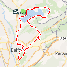
Trail Walking of 9.4 km to be discovered at Bourgogne-Franche-Comté, Territoire-de-Belfort, Belfort. This trail is proposed by benoit747.

Description

rando balisée rond vert, rectangle jaune.
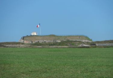
Une ballade sympa sur une demi journée qui vous permettra de découvrir les fortifications de Belfort

Elevation profile

Photos

Points of interest

Point of interest Belfort - la tour de la miotte - Photo
benoit747
Point of interest Belfort - le lion de belfort - Photo
benoit747

Positioning

Country:
France
Region :
Bourgogne-Franche-Comté
Department/Province :
Territoire-de-Belfort
Municipality :
Belfort
Location:
Unknown
Start:(UTM)
339628 ; 5279886 (32T) N.

Trails nearby

Trail Walking Belfort - Offemont - La ballade des Champs Cerisiers - Photo
Walking
bmorel@orange.fr

Walking

Easy
(1)
Belfort, Bourgogne-Franche-Comté, Territoire-de-Belfort, France
8.8 km | 10.8 km-effort
Unknown
Yes
Trail Walking Sermamagny - Veronne PC - Photo
Walking
Papamoju

Walking

Very easy
(2)
Sermamagny, Bourgogne-Franche-Comté, Territoire-de-Belfort, France
8.1 km | 9 km-effort
1h 59min
Yes
Trail On foot Offemont - Sentier de la Roselière - Photo
On foot
PRO

On foot

Easy
Offemont, Bourgogne-Franche-Comté, Territoire-de-Belfort, France
3.9 km | 4.3 km-effort
58min
Yes
Trail Mountain bike Vézelois - 1er tour avec Olivier - Photo
Mountain bike
jibus90

Mountain bike

Easy
(1)
Vézelois, Bourgogne-Franche-Comté, Territoire-de-Belfort, France
38 km | 47 km-effort
2h 59min
Yes
Trail Walking Essert - Essert - Petit Salbert - Photo
Walking
Papamoju

Walking

Very easy
(1)
Essert, Bourgogne-Franche-Comté, Territoire-de-Belfort, France
7.4 km | 10.2 km-effort
2h 10min
Yes
Trail Mountain bike Belfort - tour de la miotte Blingarno  - Photo
Mountain bike
arno90000

Mountain bike

Medium
Belfort, Bourgogne-Franche-Comté, Territoire-de-Belfort, France
10.5 km | 12.4 km-effort
52min
Yes
Trail Mountain bike Belfort - Transterritoire de Belfort 2011 - Photo
Mountain bike
tracegps

Mountain bike

Difficult
Belfort, Bourgogne-Franche-Comté, Territoire-de-Belfort, France
71 km | 91 km-effort
5h 0min
Yes
Trail Walking Belfort - Marche JO Belfort Couthenans - Photo
Walking
ISATR

Walking

Difficult
Belfort, Bourgogne-Franche-Comté, Territoire-de-Belfort, France
19.1 km | 23 km-effort
5h 19min
No
Trail Walking Sermamagny - Le Malsaucy - Photo
Walking
ISATR

Walking

Very easy
Sermamagny, Bourgogne-Franche-Comté, Territoire-de-Belfort, France
9.7 km | 11.2 km-effort
2h 10min
Yes


Close
My subscriptions