


duranne 21 09

yvetteroman
User
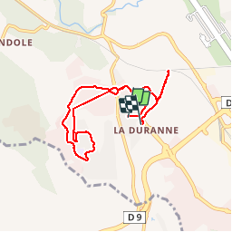

Length
7.6 km

Max alt
175 m

Uphill gradient
85 m
Km-Effort
8.8 km

Min alt
103 m

Downhill gradient
86 m
Boucle
No
Creation date :
2014-12-10 00:00:00.0
Updated on :
2014-12-10 00:00:00.0
49m
Difficulty : Unknown

FREE GPS app for hiking
 SityTrail
IGN / Geographical institutes
SityTrail Plus
The world is yours!
About
Trail Running of 7.6 km to be discovered at Provence-Alpes-Côte d'Azur, Bouches-du-Rhône, Aix-en-Provence. This trail is proposed by yvetteroman.
Description
course y
Positioning
Country:
France
Region :
Provence-Alpes-Côte d'Azur
Department/Province :
Bouches-du-Rhône
Municipality :
Aix-en-Provence
Location:
Unknown
Start:(Dec)
Start:(UTM)
690219 ; 4818127 (31T) N.
Comments