


2012-09-22 12h33m22

yolig56
User
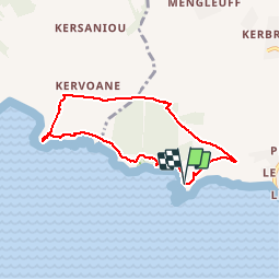

Length
6.3 km

Max alt
110 m

Uphill gradient
166 m
Km-Effort
8.5 km

Min alt
19 m

Downhill gradient
161 m
Boucle
Yes
Creation date :
2016-03-09 00:00:00.0
Updated on :
2016-03-09 00:00:00.0
1h40
Difficulty : Easy

FREE GPS app for hiking
 SityTrail
IGN / Geographical institutes
SityTrail Plus
The world is yours!
About
Trail Walking of 6.3 km to be discovered at Brittany, Finistère, Telgruc-sur-Mer. This trail is proposed by yolig56.
Positioning
Country:
France
Region :
Brittany
Department/Province :
Finistère
Municipality :
Telgruc-sur-Mer
Location:
Unknown
Start:(Dec)
Start:(UTM)
396654 ; 5341574 (30U) N.
Comments
bel environnement , très bonne balade