


Chevannes

i20
User
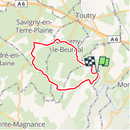

Length
10.5 km

Max alt
307 m

Uphill gradient
143 m
Km-Effort
12.4 km

Min alt
232 m

Downhill gradient
147 m
Boucle
Yes
Creation date :
2014-12-10 00:00:00.0
Updated on :
2014-12-10 00:00:00.0
--
Difficulty : Unknown

FREE GPS app for hiking
 SityTrail
IGN / Geographical institutes
SityTrail Plus
The world is yours!
About
Trail Other activity of 10.5 km to be discovered at Bourgogne-Franche-Comté, Yonne, Sainte-Magnance. This trail is proposed by i20.
Positioning
Country:
France
Region :
Bourgogne-Franche-Comté
Department/Province :
Yonne
Municipality :
Sainte-Magnance
Location:
Unknown
Start:(Dec)
Start:(UTM)
585073 ; 5258456 (31T) N.
Comments