


Randoguide

JackyDegueldre
User
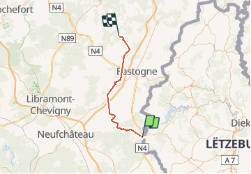

Length
47 km

Max alt
546 m

Uphill gradient
950 m
Km-Effort
59 km

Min alt
366 m

Downhill gradient
901 m
Boucle
No
Creation date :
2014-12-10 00:00:00.0
Updated on :
2014-12-10 00:00:00.0
--
Difficulty : Unknown

FREE GPS app for hiking
 SityTrail
IGN / Geographical institutes
SityTrail Plus
The world is yours!
About
Trail Other activity of 47 km to be discovered at Unknown, Canton Redange, Rambrouch. This trail is proposed by JackyDegueldre.
Positioning
Country:
Luxembourg
Region :
Unknown
Department/Province :
Canton Redange
Municipality :
Rambrouch
Location:
Unknown
Start:(Dec)
Start:(UTM)
697197 ; 5523649 (31U) N.
Comments