


69 mornant réelle

trietsch
User

Length
14.1 km

Max alt
446 m

Uphill gradient
263 m
Km-Effort
17.6 km

Min alt
333 m

Downhill gradient
262 m
Boucle
Yes
Creation date :
2016-03-09 00:00:00.0
Updated on :
2021-07-18 07:34:48.812
4h16
Difficulty : Unknown

FREE GPS app for hiking
 SityTrail
IGN / Geographical institutes
SityTrail Plus
The world is yours!
About
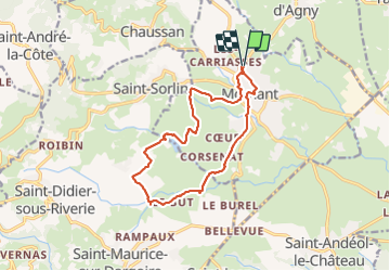
Trail Walking of 14.1 km to be discovered at Auvergne-Rhône-Alpes, Rhône, Mornant. This trail is proposed by trietsch.
Positioning
Country:
France
Region :
Auvergne-Rhône-Alpes
Department/Province :
Rhône
Municipality :
Mornant
Location:
Unknown
Start:(Dec)
Start:(UTM)
630077 ; 5053785 (31T) N.
Comments