


transferts 4-5

jcm17
User
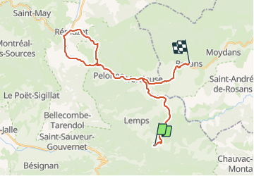

Length
32 km

Max alt
850 m

Uphill gradient
733 m
Km-Effort
42 km

Min alt
441 m

Downhill gradient
883 m
Boucle
No
Creation date :
2014-12-10 00:00:00.0
Updated on :
2014-12-10 00:00:00.0
--
Difficulty : Unknown

FREE GPS app for hiking
 SityTrail
IGN / Geographical institutes
SityTrail Plus
The world is yours!
About
Trail Other activity of 32 km to be discovered at Auvergne-Rhône-Alpes, Drôme, Montferrand-la-Fare. This trail is proposed by jcm17.
Positioning
Country:
France
Region :
Auvergne-Rhône-Alpes
Department/Province :
Drôme
Municipality :
Montferrand-la-Fare
Location:
Unknown
Start:(Dec)
Start:(UTM)
694313 ; 4911784 (31T) N.
Comments