Trail Walking Ghandruk - ABC 12 - Photo
 MickToul
MickToul

User

© OpenStreetMap contributors
Length
Length
5.6 km
Max alt
Max alt
2008 m
Uphill gradient
Uphill gradient
482 m
Km-Effort
Km-Effort  
12.8 km
Min alt
Min alt
1312 m
Downhill gradient
Downhill gradient
721 m
Boucle
Boucle
No
Creation date :
2019-03-02 12:20:16.547
Updated on :
2019-03-02 12:20:16.558

(0 Reviews)

Walking
Walking
2h32
Difficulty : Medium

Scan this QR Code to open this trail in the SityTrail application

FREE GPS app for hiking

Logo SityTrail SityTrail

IGN / Geographical institutes

Download SityTrail from the App Store Download SityTrail from Google Play

Logo SityTrail SityTrail Plus

The world is yours!

Download SityTrail from the App Store Download SityTrail from Google Play Download SityTrail on Huawei AppGallery

About

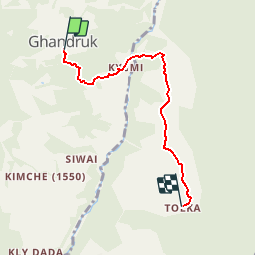
Trail Walking of 5.6 km to be discovered at Unknown, Kaski, Ghandruk. This trail is proposed by MickToul.

Description

Gandrung Tolka

Elevation profile

Points of interest

Point of interest Lumle - Tolka - Photo
MickToul
LUMLE 
Point of interest Lumle - Landrung - Photo
MickToul
LUMLE 
Point of interest Ghandruk - Kiumi - Photo
MickToul
GHANDRUK 
Point of interest Ghandruk - Gandrung - Photo
MickToul
GHANDRUK 

Positioning

Country:
Nepal
Region :
Unknown
Department/Province :
Kaski
Municipality :
Ghandruk
Location:
Unknown
Start:(UTM)
775203 ; 3142025 (44R) N.


Close
My subscriptions