


Lelex - Faucille

svp59
User
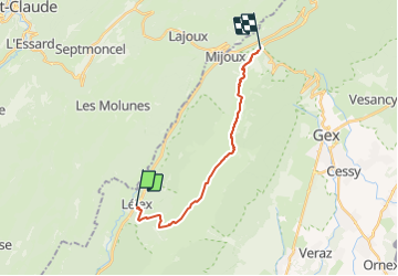

Length
14.8 km

Max alt
1681 m

Uphill gradient
999 m
Km-Effort
27 km

Min alt
890 m

Downhill gradient
573 m
Boucle
No
Creation date :
2014-12-10 00:00:00.0
Updated on :
2014-12-10 00:00:00.0
5h50
Difficulty : Unknown

FREE GPS app for hiking
 SityTrail
IGN / Geographical institutes
SityTrail Plus
The world is yours!
About
Trail Walking of 14.8 km to be discovered at Auvergne-Rhône-Alpes, Ain, Lélex. This trail is proposed by svp59.
Positioning
Country:
France
Region :
Auvergne-Rhône-Alpes
Department/Province :
Ain
Municipality :
Lélex
Location:
Unknown
Start:(Dec)
Start:(UTM)
726430 ; 5131822 (31T) N.
Comments