


2012-10-10 Rando CVA Vosges du Nord

holtzv
User GUIDE
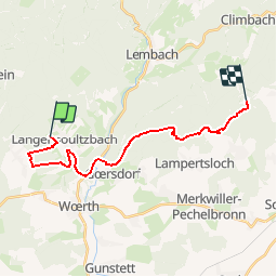

Length
18.1 km

Max alt
468 m

Uphill gradient
508 m
Km-Effort
25 km

Min alt
170 m

Downhill gradient
510 m
Boucle
No
Creation date :
2014-12-10 00:00:00.0
Updated on :
2014-12-10 00:00:00.0
--
Difficulty : Unknown

FREE GPS app for hiking
 SityTrail
IGN / Geographical institutes
SityTrail Plus
The world is yours!
About
Trail Equestrian of 18.1 km to be discovered at Grand Est, Bas-Rhin, Langensoultzbach. This trail is proposed by holtzv.
Positioning
Country:
France
Region :
Grand Est
Department/Province :
Bas-Rhin
Municipality :
Langensoultzbach
Location:
Unknown
Start:(Dec)
Start:(UTM)
406729 ; 5424777 (32U) N.
Comments