


Dentelles de Motmiriail

psesjs
User
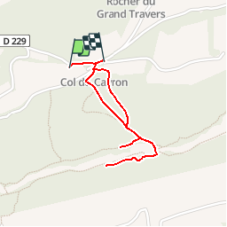

Length
1.8 km

Max alt
579 m

Uphill gradient
198 m
Km-Effort
4.4 km

Min alt
393 m

Downhill gradient
191 m
Boucle
Yes
Creation date :
2014-12-10 00:00:00.0
Updated on :
2014-12-10 00:00:00.0
--
Difficulty : Unknown

FREE GPS app for hiking
 SityTrail
IGN / Geographical institutes
SityTrail Plus
The world is yours!
About
Trail Other activity of 1.8 km to be discovered at Provence-Alpes-Côte d'Azur, Vaucluse, Gigondas. This trail is proposed by psesjs.
Positioning
Country:
France
Region :
Provence-Alpes-Côte d'Azur
Department/Province :
Vaucluse
Municipality :
Gigondas
Location:
Unknown
Start:(Dec)
Start:(UTM)
661785 ; 4891499 (31T) N.
Comments