


Peyrissinime 2012

ikusen26@gmail.com
User
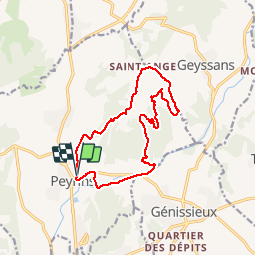

Length
14 km

Max alt
408 m

Uphill gradient
381 m
Km-Effort
19.1 km

Min alt
203 m

Downhill gradient
374 m
Boucle
Yes
Creation date :
2014-12-10 00:00:00.0
Updated on :
2014-12-10 00:00:00.0
--
Difficulty : Unknown

FREE GPS app for hiking
 SityTrail
IGN / Geographical institutes
SityTrail Plus
The world is yours!
About
Trail Other activity of 14 km to be discovered at Auvergne-Rhône-Alpes, Drôme, Peyrins. This trail is proposed by ikusen26@gmail.com.
Positioning
Country:
France
Region :
Auvergne-Rhône-Alpes
Department/Province :
Drôme
Municipality :
Peyrins
Location:
Unknown
Start:(Dec)
Start:(UTM)
661284 ; 4995382 (31T) N.
Comments
bien Venez découvrir le SityGuide St pancrase dans l'application gratuite SityTrail http://bit.ly/12s5alW