


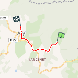
Mine - calvaire

Chapatann
User

Length
2.9 km

Max alt
1004 m

Uphill gradient
122 m
Km-Effort
4.4 km

Min alt
908 m

Downhill gradient
87 m
Boucle
No
Creation date :
2014-12-10 00:00:00.0
Updated on :
2014-12-10 00:00:00.0
--
Difficulty : Medium

FREE GPS app for hiking
 SityTrail
IGN / Geographical institutes
SityTrail Plus
The world is yours!
About
Trail Walking of 2.9 km to be discovered at Auvergne-Rhône-Alpes, Haute-Loire, Ally. This trail is proposed by Chapatann.


Positioning
Country:
France
Region :
Auvergne-Rhône-Alpes
Department/Province :
Haute-Loire
Municipality :
Ally
Location:
Unknown
Start:(Dec)
Start:(UTM)
526263 ; 5000347 (31T) N.
Comments