Trail Walking Vaudancourt - Vaudancourt - Breuil et Boury - Photo

Vaudancourt - Breuil et Boury

 marcel.F
marcel.F

User

© OpenStreetMap contributors
Length
Length
11.8 km
Max alt
Max alt
137 m
Uphill gradient
Uphill gradient
187 m
Km-Effort
Km-Effort  
14.3 km
Min alt
Min alt
58 m
Downhill gradient
Downhill gradient
187 m
Boucle
Boucle
Yes
Creation date :
2016-04-28 00:00:00.0
Updated on :
2019-04-20 15:59:09.906

(1 Reviews)

Walking
Walking
3h05
Difficulty : Easy

Scan this QR Code to open this trail in the SityTrail application

FREE GPS app for hiking

Logo SityTrail SityTrail

IGN / Geographical institutes

Download SityTrail from the App Store Download SityTrail from Google Play

Logo SityTrail SityTrail World

The world is yours!

Download SityTrail from the App Store Download SityTrail from Google Play Download SityTrail on Huawei AppGallery

About

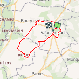
Trail Walking of 11.8 km to be discovered at Hauts-de-France, Oise, Vaudancourt. This trail is proposed by marcel.F.

Description

Départ parking de la mairie de Vaudancourt
itinéraire via Breuil et Boury en Vexin

Elevation profile

Photos

Points of interest

Point of interest Boury-en-Vexin - Chateau de Boury en Vexin - Photo
marcel.F

Positioning

Country:
France
Region :
Hauts-de-France
Department/Province :
Oise
Municipality :
Vaudancourt
Location:
Unknown
Start:(Dec)
Start:(UTM)
409439 ; 5454191 (31U) N.

Comments

Please log in to post a review or rate the element


sympa merci


Trails nearby

Trail Walking Boury-en-Vexin - Boury en Vexin - Hérouval - Photo
Walking
marcel.F

Walking

Easy
(3)
Boury-en-Vexin, Hauts-de-France, Oise, France
10.9 km | 12.9 km-effort
2h 49min
Yes
Trail Nordic walking Boury-en-Vexin - Marche Nordique 75 Boury en Vexin - Photo
Nordic walking
marcel.F

Nordic walking

Easy
(1)
Boury-en-Vexin, Hauts-de-France, Oise, France
10.3 km | 12.6 km-effort
1h 30min
Yes
Trail Nordic walking Courcelles-lès-Gisors - Marche Nordique 71 Courcelles les Gisors - Photo
Nordic walking
marcel.F

Nordic walking

Very easy
(2)
Courcelles-lès-Gisors, Hauts-de-France, Oise, France
9.2 km | 10.9 km-effort
1h 26min
Yes
Trail Walking Chambors - CHAMBORS - Lattainville-Delincourt-Reillly - Photo
Walking
marcel.F

Walking

Very easy
(1)
Chambors, Hauts-de-France, Oise, France
12.3 km | 15.2 km-effort
2h 54min
Yes
Trail Nordic walking Chambors - Marche Nordique 61 Chambors - Photo
Nordic walking
marcel.F

Nordic walking

Easy
(1)
Chambors, Hauts-de-France, Oise, France
8.4 km | 10.3 km-effort
1h 30min
Yes
Trail Walking Montjavoult - Montjavoult - Vaudancourt - Photo
Walking
marcel.F

Walking

Easy
(1)
Montjavoult, Hauts-de-France, Oise, France
10.2 km | 12.2 km-effort
2h 39min
Yes
Trail Walking Chambors - Chambors - le dolmen 12 - Photo
Walking
marcel.F

Walking

Easy
(1)
Chambors, Hauts-de-France, Oise, France
12.4 km | 16 km-effort
3h 31min
Yes
Trail Walking Guerny - Gisancourt - Notre Dame du Chêne - Photo
Walking
marcel.F

Walking

Easy
(2)
Guerny, Normandy, Eure, France
11.6 km | 13.9 km-effort
3h 2min
Yes
Trail Walking Chambors - Chambors - le dolmen 9 - Photo
Walking
marcel.F

Walking

Easy
(4)
Chambors, Hauts-de-France, Oise, France
9.3 km | 12.1 km-effort
2h 38min
Yes


Close
My subscriptions