


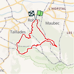
Combe de Vidauque, depuis Robion

jmheydorff
User


5h05
Difficulty : Medium

FREE GPS app for hiking
 SityTrail
IGN / Geographical institutes
SityTrail Plus
The world is yours!
About
Trail Walking of 15 km to be discovered at Provence-Alpes-Côte d'Azur, Vaucluse, Robion. This trail is proposed by jmheydorff.
Description
Pkg Théâtre de verdure SE de Robion (alt. 160m): monter SE rejoindre la ligne de crête entre les vallons Peyrot et de la petite Trappe (cotes 426 et 502).
Descendre dans la Vallon du Colombier, qui se prolonge par la Combe de Vidauque; revenir N par Taillades; aux abords, remonter SE la gorge de Badarel; puis N vers le Castelas (fortes montée et descente) et les Rochers de Baude, d''où l''on descend au pkg
Positioning
Comments