Trail Walking Théméricourt - Théméricourt - La vallée de l''Aubette - Photo

Théméricourt - La vallée de l''Aubette

 marcel.F
marcel.F

User

© OpenStreetMap contributors
Length
Length
10.4 km
Max alt
Max alt
121 m
Uphill gradient
Uphill gradient
141 m
Km-Effort
Km-Effort  
12.3 km
Min alt
Min alt
53 m
Downhill gradient
Downhill gradient
141 m
Boucle
Boucle
Yes
Creation date :
2014-12-10 00:00:00.0
Updated on :
2014-12-10 00:00:00.0

(1 Reviews)

Walking
Walking
2h42
Difficulty : Easy

Scan this QR Code to open this trail in the SityTrail application

FREE GPS app for hiking

Logo SityTrail SityTrail

IGN / Geographical institutes

Download SityTrail from the App Store Download SityTrail from Google Play

Logo SityTrail SityTrail World

The world is yours!

Download SityTrail from the App Store Download SityTrail from Google Play Download SityTrail on Huawei AppGallery

About

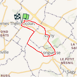
Trail Walking of 10.4 km to be discovered at Ile-de-France, Val-d'Oise, Théméricourt. This trail is proposed by marcel.F.

Description

Boucle au départ de Théméricourt
(parking face au musée)
par Vigny et Longuesse

Elevation profile

Photos

Points of interest

Point of interest Vigny - chateau de Vigny - Photo
marcel.F
Point of interest Théméricourt - chateau de Théméricourt - Photo
marcel.F

Positioning

Country:
France
Region :
Ile-de-France
Department/Province :
Val-d'Oise
Municipality :
Théméricourt
Location:
Unknown
Start:(UTM)
419365 ; 5437692 (31U) N.

Comments

Please log in to post a review or rate the element


Trails nearby

Trail Nordic walking Frémainville - Forêt de Galluis - Photo
Nordic walking
Fky78

Nordic walking

Easy
(1)
Frémainville, Ile-de-France, Val-d'Oise, France
6 km | 7.3 km-effort
1h 20min
Yes
Trail Walking Frémainville - Fremainville marche 6km - Photo
Walking
unirega

Walking

Medium
(2)
Frémainville, Ile-de-France, Val-d'Oise, France
5.8 km | 7.9 km-effort
1h 20min
No
Trail Walking Le Perchay - le perchay etang de valliere santeuil - Photo
Walking
jeang95

Walking

Very easy
(2)
Le Perchay, Ile-de-France, Val-d'Oise, France
6.9 km | 8.1 km-effort
1h 34min
Yes
Trail Walking Wy-dit-Joli-Village - Wy dit joli village-Guiry-Gadancourt (boucle) - Photo
Walking
mictar78

Walking

Easy
(1)
Wy-dit-Joli-Village, Ile-de-France, Val-d'Oise, France
11.1 km | 13.3 km-effort
2h 32min
Yes
Trail Walking Commeny - Commeny - L'eau et le pain - Photo
Walking
marcel.F

Walking

Easy
(4)
Commeny, Ile-de-France, Val-d'Oise, France
13.2 km | 15.1 km-effort
3h 18min
Yes
Trail Walking Vigny - Ligny - Photo
Walking
avdem

Walking

Easy
Vigny, Ile-de-France, Val-d'Oise, France
9.2 km | 11 km-effort
2h 8min
Yes
Trail Walking Commeny - Kimrny - Photo
Walking
avdem

Walking

Very easy
Commeny, Ile-de-France, Val-d'Oise, France
13.8 km | 15.7 km-effort
3h 21min
Yes
Trail On foot Santeuil - Le tour du Grand Paris via le GR1 - Etape 4  - Photo
On foot
chessyca

On foot

Difficult
Santeuil, Ile-de-France, Val-d'Oise, France
34 km | 39 km-effort
8h 58min
No
Trail On foot Le Perchay - Boucle du Perchay - Photo
On foot
PRO

On foot

Easy
Le Perchay, Ile-de-France, Val-d'Oise, France
13.2 km | 15 km-effort
3h 24min
Yes


Close
My subscriptions