


autour de Sté eu l'amie

colber
User
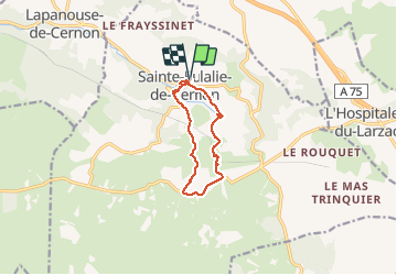

Length
10 km

Max alt
850 m

Uphill gradient
297 m
Km-Effort
13.9 km

Min alt
575 m

Downhill gradient
297 m
Boucle
Yes
Creation date :
2014-12-10 00:00:00.0
Updated on :
2014-12-10 00:00:00.0
2h49
Difficulty : Unknown

FREE GPS app for hiking
 SityTrail
IGN / Geographical institutes
SityTrail Plus
The world is yours!
About
Trail Walking of 10 km to be discovered at Occitania, Aveyron, Sainte-Eulalie-de-Cernon. This trail is proposed by colber.
Description
Balade facile
Photos


Positioning
Country:
France
Region :
Occitania
Department/Province :
Aveyron
Municipality :
Sainte-Eulalie-de-Cernon
Location:
Unknown
Start:(Dec)
Start:(UTM)
510980 ; 4870017 (31T) N.
Comments