Trail Walking Ventron - ODEREN - COL DU COLLET - MEUSFOUX - Photo

ODEREN - COL DU COLLET - MEUSFOUX

© OpenStreetMap contributors
Length
Length
9.9 km
Max alt
Max alt
1060 m
Uphill gradient
Uphill gradient
419 m
Km-Effort
Km-Effort  
15.5 km
Min alt
Min alt
763 m
Downhill gradient
Downhill gradient
418 m
Boucle
Boucle
Yes
Creation date :
2018-10-13 05:53:34.946
Updated on :
2018-10-13 05:53:34.956

(0 Reviews)

Walking
Walking
3h41
Difficulty : Medium

Scan this QR Code to open this trail in the SityTrail application

FREE GPS app for hiking

Logo SityTrail SityTrail

IGN / Geographical institutes

Download SityTrail from the App Store Download SityTrail from Google Play

Logo SityTrail SityTrail Plus

The world is yours!

Download SityTrail from the App Store Download SityTrail from Google Play Download SityTrail on Huawei AppGallery

About

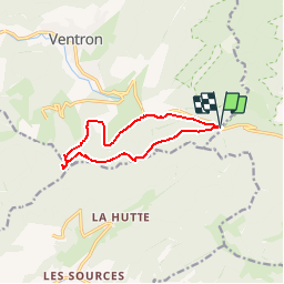
Trail Walking of 9.9 km to be discovered at Grand Est, Vosges, Ventron. This trail is proposed by patrickbeyrath.

Description

P Col d'Oderen-Rond rouge Col du Page - Col du Collet-Abri du Forgoutte - Circuit bleu jusqu'au croisement Col du Collet-Hermitage Frère Joseph et prendre Circuit Rouge Meusfoux et au bout rect Bleu blanc bleu jusqu'au parking Col d'Oderen

Elevation profile

Positioning

Country:
France
Region :
Grand Est
Department/Province :
Vosges
Municipality :
Ventron
Location:
Unknown
Start:(UTM)
344401 ; 5309813 (32T) N.


Close
My subscriptions