Trail Walking Dambach-la-Ville - La traversée du massif du Bernstein - Photo

La traversée du massif du Bernstein

© OpenStreetMap contributors
Length
Length
13.9 km
Max alt
Max alt
551 m
Uphill gradient
Uphill gradient
508 m
Km-Effort
Km-Effort  
21 km
Min alt
Min alt
244 m
Downhill gradient
Downhill gradient
508 m
Boucle
Boucle
Yes
Creation date :
2014-12-10 00:00:00.0
Updated on :
2014-12-10 00:00:00.0

(1 Reviews)

Walking
Walking
5h01
Difficulty : Medium

Scan this QR Code to open this trail in the SityTrail application

FREE GPS app for hiking

Logo SityTrail SityTrail

IGN / Geographical institutes

Download SityTrail from the App Store Download SityTrail from Google Play

Logo SityTrail SityTrail Plus

The world is yours!

Download SityTrail from the App Store Download SityTrail from Google Play Download SityTrail on Huawei AppGallery

About

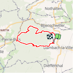
Trail Walking of 13.9 km to be discovered at Grand Est, Bas-Rhin, Dambach-la-Ville. This trail is proposed by VacheKiri67.

Description

Balisage : chevalet rouge - croix jaune - croix rouge.
Faite le 21/10/2012 en 5h00 (dont 0h35 de pauses) avec notre fils de 8 ans.
La durée rallongée et les zigzags proviennent de la cueillette de champignons ! Sa durée annoncée étant de 3h30.
Plus de détails : Passion Vosges - Alsace centrale N°3 Page 49 : Traversée du massif du Bernstein.

Elevation profile

Photos

Positioning

Country:
France
Region :
Grand Est
Department/Province :
Bas-Rhin
Municipality :
Dambach-la-Ville
Location:
Unknown
Start:(UTM)
382871 ; 5353903 (32U) N.

Comments

Please log in to post a review or rate the element


Close
My subscriptions