


Rieisse - Roc des Hourtous

laet
User
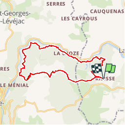

Length
16.5 km

Max alt
935 m

Uphill gradient
715 m
Km-Effort
26 km

Min alt
446 m

Downhill gradient
715 m
Boucle
Yes
Creation date :
2019-05-26 16:16:23.149
Updated on :
2019-05-26 16:16:23.361
6h00
Difficulty : Difficult

FREE GPS app for hiking
 SityTrail
IGN / Geographical institutes
SityTrail Plus
The world is yours!
About
Trail Walking of 16.5 km to be discovered at Occitania, Lozère, La Malène. This trail is proposed by laet.
Description
Vautours en fin de parcours à Caxe
Positioning
Country:
France
Region :
Occitania
Department/Province :
Lozère
Municipality :
La Malène
Location:
Unknown
Start:(Dec)
Start:(UTM)
523837 ; 4903843 (31T) N.
Comments
Magnifique vue sur les gorges du Tarn. Une remontée vers Caxe vertigineuse avec le vol des Vautours.