Trail Walking Meyrueis - Cabrillac - Photo
 ilur56
ilur56

User

© OpenStreetMap contributors
Length
Length
24 km
Max alt
Max alt
1255 m
Uphill gradient
Uphill gradient
674 m
Km-Effort
Km-Effort  
33 km
Min alt
Min alt
742 m
Downhill gradient
Downhill gradient
660 m
Boucle
Boucle
Yes
Creation date :
2014-12-10 00:00:00.0
Updated on :
2014-12-10 00:00:00.0

(1 Reviews)

Walking
Walking
7h09
Difficulty : Medium

Scan this QR Code to open this trail in the SityTrail application

FREE GPS app for hiking

Logo SityTrail SityTrail

IGN / Geographical institutes

Download SityTrail from the App Store Download SityTrail from Google Play

Logo SityTrail SityTrail World

The world is yours!

Download SityTrail from the App Store Download SityTrail from Google Play Download SityTrail on Huawei AppGallery

About

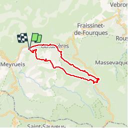
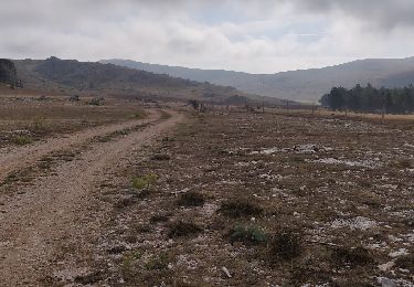
Trail Walking of 24 km to be discovered at Occitania, Lozère, Meyrueis. This trail is proposed by ilur56.

Description

Départ du camping de la Cascade vers le village de Cabrillac

Elevation profile

Positioning

Country:
France
Region :
Occitania
Department/Province :
Lozère
Municipality :
Meyrueis
Location:
Unknown
Start:(UTM)
536351 ; 4893641 (31T) N.

Comments

Please log in to post a review or rate the element


on peut éviter la route au début


Trails nearby

Trail Road bike Meyrueis - tour aigoual - Photo
Road bike
rafde210

Road bike

Medium
(1)
Meyrueis, Occitania, Lozère, France
58 km | 74 km-effort
3h 5min
No
Trail Walking Meyrueis - Meyrues à observatoire Mont Aigoual  - Photo
Walking
GUIDE
nadinebondoux

Walking

Difficult
Meyrueis, Occitania, Lozère, France
21 km | 0 m-effort
5h 58min
No
Trail On foot Meyrueis - Sentier du Château de Roquedols - Photo
On foot
PRO

On foot

Easy
Meyrueis, Occitania, Lozère, France
5 km | 6.9 km-effort
1h 33min
Yes
Trail Walking Meyrueis - Meyruis L’Esperou 26 km - Tour du mont Aigual  étape 3 - Photo
Walking
GUIDE
rvapeldo

Walking

Difficult
Meyrueis, Occitania, Lozère, France
28 km | 41 km-effort
9h 0min
No
Trail Walking Fraissinet-de-Fourques - Boucle Nîmes le Vieux  - Photo
Walking
Indi34

Walking

Easy
Fraissinet-de-Fourques, Occitania, Lozère, France
3.1 km | 4.3 km-effort
1h 0min
Yes
Trail Walking Meyrueis - meyrues l'esperouvia le mont aigoual - Photo
Walking
RoMo

Walking

Difficult
Meyrueis, Occitania, Lozère, France
31 km | 46 km-effort
8h 54min
No
Trail Walking Meyrueis - Meyruies - Gorges de la Jonte - Grotte de Dagilan - Photo
Walking
Bart2015

Walking

Medium
Meyrueis, Occitania, Lozère, France
15.2 km | 21 km-effort
4h 25min
Yes
Trail Walking Fraissinet-de-Fourques - Nime le Vieux 10 km - Photo
Walking
GUIDE
rvapeldo

Walking

Easy
Fraissinet-de-Fourques, Occitania, Lozère, France
10.3 km | 14 km-effort
3h 47min
Yes
Trail Walking Fraissinet-de-Fourques - Tour du Causse Méjean - Etape 7 - Photo
Walking
nolsim

Walking

Medium
Fraissinet-de-Fourques, Occitania, Lozère, France
24 km | 29 km-effort
6h 1min
No


Close
My subscriptions