


Plougasnou

ilur56
User

Length
21 km

Max alt
56 m

Uphill gradient
283 m
Km-Effort
25 km

Min alt
0 m

Downhill gradient
283 m
Boucle
Yes
Creation date :
2016-03-09 00:00:00.0
Updated on :
2016-03-09 00:00:00.0
5h28
Difficulty : Medium

FREE GPS app for hiking
 SityTrail
IGN / Geographical institutes
SityTrail Plus
The world is yours!
About
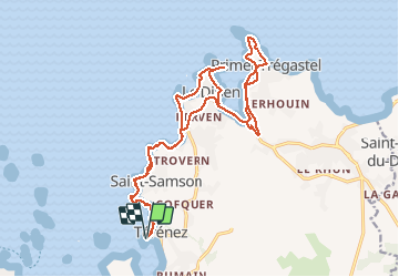
Trail Walking of 21 km to be discovered at Brittany, Finistère, Plougasnou. This trail is proposed by ilur56.
Description
Le chemin côtier sur le GR 34


Positioning
Country:
France
Region :
Brittany
Department/Province :
Finistère
Municipality :
Plougasnou
Location:
Unknown
Start:(Dec)
Start:(UTM)
437374 ; 5391880 (30U) N.
Comments