


Chagey - Bois de la Thure

ballet
User
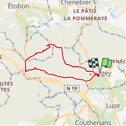

Length
10.6 km

Max alt
562 m

Uphill gradient
271 m
Km-Effort
14.2 km

Min alt
338 m

Downhill gradient
270 m
Boucle
Yes
Creation date :
2014-12-10 00:00:00.0
Updated on :
2014-12-10 00:00:00.0
2h35
Difficulty : Easy

FREE GPS app for hiking
 SityTrail
IGN / Geographical institutes
SityTrail Plus
The world is yours!
About
Trail Walking of 10.6 km to be discovered at Bourgogne-Franche-Comté, Haute-Saône, Chagey. This trail is proposed by ballet.
Positioning
Country:
France
Region :
Bourgogne-Franche-Comté
Department/Province :
Haute-Saône
Municipality :
Chagey
Location:
Unknown
Start:(Dec)
Start:(UTM)
329587 ; 5275643 (32T) N.
Comments
Rando sympa mais itinéraire tracé très incertain sur le côté nord de la colline du bois de la Thure (très escarpé)