


2012-10-19 Baronnies J2

jcm17
User
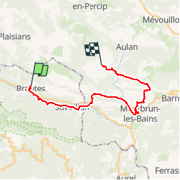

Length
25 km

Max alt
801 m

Uphill gradient
808 m
Km-Effort
35 km

Min alt
467 m

Downhill gradient
595 m
Boucle
No
Creation date :
2014-12-10 00:00:00.0
Updated on :
2014-12-10 00:00:00.0
7h27
Difficulty : Difficult

FREE GPS app for hiking
 SityTrail
IGN / Geographical institutes
SityTrail Plus
The world is yours!
About
Trail Walking of 25 km to be discovered at Provence-Alpes-Côte d'Azur, Vaucluse, Brantes. This trail is proposed by jcm17.
Description
Baronnies J2 de Brantes à Vergol
Photos


Positioning
Country:
France
Region :
Provence-Alpes-Côte d'Azur
Department/Province :
Vaucluse
Municipality :
Brantes
Location:
Unknown
Start:(Dec)
Start:(UTM)
686526 ; 4896181 (31T) N.
Comments