


2012-10-24_j7m

jcm17
User
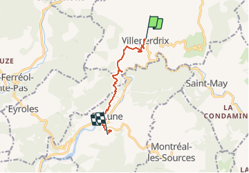

Length
8.5 km

Max alt
624 m

Uphill gradient
437 m
Km-Effort
14.3 km

Min alt
354 m

Downhill gradient
432 m
Boucle
No
Creation date :
2014-12-10 00:00:00.0
Updated on :
2014-12-10 00:00:00.0
3h06
Difficulty : Medium

FREE GPS app for hiking
 SityTrail
IGN / Geographical institutes
SityTrail Plus
The world is yours!
About
Trail Walking of 8.5 km to be discovered at Auvergne-Rhône-Alpes, Drôme, Villeperdrix. This trail is proposed by jcm17.
Description
ARDER Baronnies
mercredi 24/10/2012
de Villeperdrix à Sahune
Positioning
Country:
France
Region :
Auvergne-Rhône-Alpes
Department/Province :
Drôme
Municipality :
Villeperdrix
Location:
Unknown
Start:(Dec)
Start:(UTM)
682049 ; 4923547 (31T) N.
Comments