


38 Chartreuse Col de Bellefond

trietsch
User
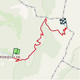

Length
5.8 km

Max alt
1886 m

Uphill gradient
913 m
Km-Effort
15 km

Min alt
977 m

Downhill gradient
7 m
Boucle
No
Creation date :
2015-06-15 00:00:00.0
Updated on :
2020-01-04 20:30:47.554
5h00
Difficulty : Medium

FREE GPS app for hiking
 SityTrail
IGN / Geographical institutes
SityTrail Plus
The world is yours!
About
Trail Walking of 5.8 km to be discovered at Auvergne-Rhône-Alpes, Isère, Saint-Pierre-de-Chartreuse. This trail is proposed by trietsch.
Description
Par le col de la saulce
Positioning
Country:
France
Region :
Auvergne-Rhône-Alpes
Department/Province :
Isère
Municipality :
Saint-Pierre-de-Chartreuse
Location:
Unknown
Start:(Dec)
Start:(UTM)
723009 ; 5023687 (31T) N.
Comments