Trail Walking Mirleft - Mirleft N°1 - Photo
© OpenStreetMap contributors
Length
Length
14.3 km
Max alt
Max alt
168 m
Uphill gradient
Uphill gradient
309 m
Km-Effort
Km-Effort  
18.4 km
Min alt
Min alt
0 m
Downhill gradient
Downhill gradient
307 m
Boucle
Boucle
Yes
Creation date :
2014-12-10 00:00:00.0
Updated on :
2014-12-10 00:00:00.0

(1 Reviews)

Walking
Walking
4h00
Difficulty : Medium

Scan this QR Code to open this trail in the SityTrail application

FREE GPS app for hiking

Logo SityTrail SityTrail

IGN / Geographical institutes

Download SityTrail from the App Store Download SityTrail from Google Play

Logo SityTrail SityTrail World

The world is yours!

Download SityTrail from the App Store Download SityTrail from Google Play Download SityTrail on Huawei AppGallery

About

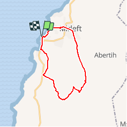
Trail Walking of 14.3 km to be discovered at Guelmim-Oued Noun, cercle d'Ifni دائرة إفني, Mirleft. This trail is proposed by papymich28.

Description

Boucle Mirleft(quartier Tayirt) -Tanamert - Tablkoukt -Sidi Mohamed Ben Abdellah - Mirleft(quartier Tayirt)

Elevation profile

Positioning

Country:
Morocco
Region :
Guelmim-Oued Noun
Department/Province :
cercle d'Ifni دائرة إفني
Municipality :
Mirleft
Location:
Unknown
Start:(UTM)
398167 ; 3272063 (29R) N.

Comments

Please log in to post a review or rate the element


Trails nearby

Trail Other activity Mirleft - Mirleft-Guelmin - Photo
Other activity
papymich28

Other activity

Very easy
Mirleft, Guelmim-Oued Noun, cercle d'Ifni دائرة إفني, Morocco
82 km | 135 km-effort
1h 0min
No
Trail Other activity Mirleft - Petite Boucle - Photo
Other activity
papymich28

Other activity

Very easy
Mirleft, Guelmim-Oued Noun, cercle d'Ifni دائرة إفني, Morocco
6.8 km | 8.6 km-effort
1h 30min
Yes
Trail Walking Mirleft - Mirleft 03 - Photo
Walking
papymich28

Walking

Easy
Mirleft, Guelmim-Oued Noun, cercle d'Ifni دائرة إفني, Morocco
12.9 km | 18.3 km-effort
3h 20min
Yes


Close
My subscriptions