


ecorando StAndré en Royans 24 11 2012

psesjs
User
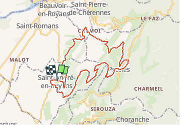

Length
22 km

Max alt
986 m

Uphill gradient
1041 m
Km-Effort
36 km

Min alt
344 m

Downhill gradient
1032 m
Boucle
Yes
Creation date :
2014-12-10 00:00:00.0
Updated on :
2014-12-10 00:00:00.0
6h05
Difficulty : Difficult

FREE GPS app for hiking
 SityTrail
IGN / Geographical institutes
SityTrail Plus
The world is yours!
About
Trail Walking of 22 km to be discovered at Auvergne-Rhône-Alpes, Isère, Saint-André-en-Royans. This trail is proposed by psesjs.
Positioning
Country:
France
Region :
Auvergne-Rhône-Alpes
Department/Province :
Isère
Municipality :
Saint-André-en-Royans
Location:
Unknown
Start:(Dec)
Start:(UTM)
684113 ; 4995159 (31T) N.
Comments