


rando à Lamenay sur Loire

kronio
User
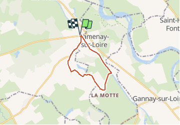

Length
8.8 km

Max alt
215 m

Uphill gradient
50 m
Km-Effort
9.5 km

Min alt
198 m

Downhill gradient
51 m
Boucle
Yes
Creation date :
2014-12-10 00:00:00.0
Updated on :
2014-12-10 00:00:00.0
2h16
Difficulty : Very easy

FREE GPS app for hiking
 SityTrail
IGN / Geographical institutes
SityTrail Plus
The world is yours!
About
Trail Walking of 8.8 km to be discovered at Bourgogne-Franche-Comté, Nièvre, Cossaye. This trail is proposed by kronio.
Description
Entre chemins champêtre et bord du canal latéral
Positioning
Country:
France
Region :
Bourgogne-Franche-Comté
Department/Province :
Nièvre
Municipality :
Cossaye
Location:
Unknown
Start:(Dec)
Start:(UTM)
542630 ; 5178805 (31T) N.
Comments