


Bâgé-le Chatel: les 3 Châteaux

robertdurand
User

Length
11.1 km

Max alt
213 m

Uphill gradient
137 m
Km-Effort
12.9 km

Min alt
184 m

Downhill gradient
137 m
Boucle
Yes
Creation date :
2014-12-10 00:00:00.0
Updated on :
2014-12-10 00:00:00.0
2h30
Difficulty : Easy

FREE GPS app for hiking
 SityTrail
IGN / Geographical institutes
SityTrail Plus
The world is yours!
About
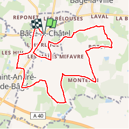
Trail Walking of 11.1 km to be discovered at Auvergne-Rhône-Alpes, Ain, Bâgé-le-Châtel. This trail is proposed by robertdurand.
Description
La communauté de communes du pays de Bâgé propose un circuit qui permet de voir les Châteaux de Bâgé-le-Châtel, de Montépin et de la Grifonnière
Positioning
Country:
France
Region :
Auvergne-Rhône-Alpes
Department/Province :
Ain
Municipality :
Bâgé-le-Châtel
Location:
Unknown
Start:(Dec)
Start:(UTM)
648545 ; 5130050 (31T) N.
Comments