


Source de l''infernet

domol
User
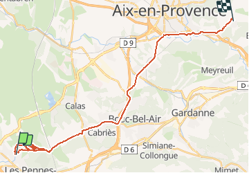

Length
34 km

Max alt
232 m

Uphill gradient
533 m
Km-Effort
41 km

Min alt
90 m

Downhill gradient
443 m
Boucle
No
Creation date :
2015-04-01 00:00:00.0
Updated on :
2015-04-01 00:00:00.0
3h07
Difficulty : Unknown

FREE GPS app for hiking
 SityTrail
IGN / Geographical institutes
SityTrail Plus
The world is yours!
About
Trail Walking of 34 km to be discovered at Provence-Alpes-Côte d'Azur, Bouches-du-Rhône, Les Pennes-Mirabeau. This trail is proposed by domol.
Description
balade
Positioning
Country:
France
Region :
Provence-Alpes-Côte d'Azur
Department/Province :
Bouches-du-Rhône
Municipality :
Les Pennes-Mirabeau
Location:
Unknown
Start:(Dec)
Start:(UTM)
685796 ; 4810593 (31T) N.
Comments