


saint esteve

colber
User
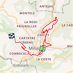

Length
18.2 km

Max alt
527 m

Uphill gradient
484 m
Km-Effort
24 km

Min alt
352 m

Downhill gradient
364 m
Boucle
No
Creation date :
2014-12-10 00:00:00.0
Updated on :
2014-12-10 00:00:00.0
3h46
Difficulty : Medium

FREE GPS app for hiking
 SityTrail
IGN / Geographical institutes
SityTrail Plus
The world is yours!
About
Trail Walking of 18.2 km to be discovered at Occitania, Aveyron, Millau. This trail is proposed by colber.
Description
Rando tres facile
Positioning
Country:
France
Region :
Occitania
Department/Province :
Aveyron
Municipality :
Millau
Location:
Unknown
Start:(Dec)
Start:(UTM)
506626 ; 4882410 (31T) N.
Comments