


Course à pied

32mike32
User

Length
11.1 km

Max alt
141 m

Uphill gradient
203 m
Km-Effort
13.8 km

Min alt
43 m

Downhill gradient
197 m
Boucle
No
Creation date :
2017-10-19 00:00:00.0
Updated on :
2017-10-19 00:00:00.0
1h00
Difficulty : Unknown

FREE GPS app for hiking
 SityTrail
IGN / Geographical institutes
SityTrail Plus
The world is yours!
About
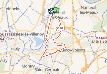
Trail Running of 11.1 km to be discovered at Ile-de-France, Seine-et-Marne, Mareuil-lès-Meaux. This trail is proposed by 32mike32.
Positioning
Country:
France
Region :
Ile-de-France
Department/Province :
Seine-et-Marne
Municipality :
Mareuil-lès-Meaux
Location:
Unknown
Start:(Dec)
Start:(UTM)
489450 ; 5419164 (31U) N.
Comments