


cilaos

Equedreu
User
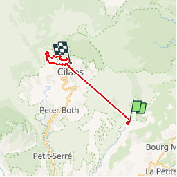

Length
25 km

Max alt
2175 m

Uphill gradient
3562 m
Km-Effort
70 km

Min alt
600 m

Downhill gradient
2987 m
Boucle
No
Creation date :
2016-03-09 00:00:00.0
Updated on :
2016-03-09 00:00:00.0
5m
Difficulty : Medium

FREE GPS app for hiking
 SityTrail
IGN / Geographical institutes
SityTrail Plus
The world is yours!
About
Trail Walking of 25 km to be discovered at Réunion, Unknown, Le Tampon. This trail is proposed by Equedreu.
Positioning
Country:
France
Region :
Réunion
Department/Province :
Unknown
Municipality :
Le Tampon
Location:
Unknown
Start:(Dec)
Start:(UTM)
347597 ; 7656809 (40K) S.
Comments