


2012-12-27 Marche Heidenkopf avec Camille et Matthieu

holtzv
User GUIDE
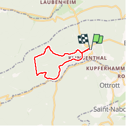

Length
9.4 km

Max alt
791 m

Uphill gradient
541 m
Km-Effort
16.6 km

Min alt
339 m

Downhill gradient
537 m
Boucle
Yes
Creation date :
2014-12-10 00:00:00.0
Updated on :
2014-12-10 00:00:00.0
3h15
Difficulty : Very easy

FREE GPS app for hiking
 SityTrail
IGN / Geographical institutes
SityTrail Plus
The world is yours!
About
Trail Walking of 9.4 km to be discovered at Grand Est, Bas-Rhin, Bœrsch. This trail is proposed by holtzv.
Positioning
Country:
France
Region :
Grand Est
Department/Province :
Bas-Rhin
Municipality :
Bœrsch
Location:
Unknown
Start:(Dec)
Start:(UTM)
382495 ; 5370136 (32U) N.
Comments