


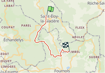
st eloy - chalembel

fredspa
User

Length
8.6 km

Max alt
1090 m

Uphill gradient
112 m
Km-Effort
10.2 km

Min alt
974 m

Downhill gradient
154 m
Boucle
No
Creation date :
2014-12-10 00:00:00.0
Updated on :
2014-12-10 00:00:00.0
2h13
Difficulty : Medium

FREE GPS app for hiking
 SityTrail
IGN / Geographical institutes
SityTrail Plus
The world is yours!
About
Trail Walking of 8.6 km to be discovered at Auvergne-Rhône-Alpes, Puy-de-Dôme, Saint-Éloy-la-Glacière. This trail is proposed by fredspa.
Photos


Positioning
Country:
France
Region :
Auvergne-Rhône-Alpes
Department/Province :
Puy-de-Dôme
Municipality :
Saint-Éloy-la-Glacière
Location:
Unknown
Start:(Dec)
Start:(UTM)
544479 ; 5045678 (31T) N.
Comments