


2013-01-12_chalautre

jcm17
User
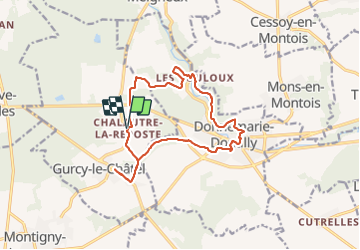

Length
14.3 km

Max alt
145 m

Uphill gradient
242 m
Km-Effort
17.5 km

Min alt
74 m

Downhill gradient
245 m
Boucle
Yes
Creation date :
2014-12-10 00:00:00.0
Updated on :
2014-12-10 00:00:00.0
3h48
Difficulty : Easy

FREE GPS app for hiking
 SityTrail
IGN / Geographical institutes
SityTrail Plus
The world is yours!
About
Trail Walking of 14.3 km to be discovered at Ile-de-France, Seine-et-Marne, Gurcy-le-Châtel. This trail is proposed by jcm17.
Description
rando SLV7 du 12 janvier à Chalautre et Gurcy


Positioning
Country:
France
Region :
Ile-de-France
Department/Province :
Seine-et-Marne
Municipality :
Gurcy-le-Châtel
Location:
Unknown
Start:(Dec)
Start:(UTM)
506813 ; 5369733 (31U) N.
Comments
Tiens, voilà un tracé qui ressemble au mien ;o)Ai mis que 2 étoiles (peu mieux faire), car pour en avoir +, faudrait qlqs photos ;o)