


Projet Lantosque

jlrayon
User

Length
12.3 km

Max alt
745 m

Uphill gradient
633 m
Km-Effort
21 km

Min alt
460 m

Downhill gradient
633 m
Boucle
Yes
Creation date :
2014-12-10 00:00:00.0
Updated on :
2014-12-10 00:00:00.0
3h00
Difficulty : Medium

FREE GPS app for hiking
 SityTrail
IGN / Geographical institutes
SityTrail Plus
The world is yours!
About
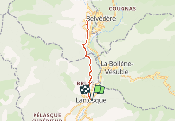
Trail Walking of 12.3 km to be discovered at Provence-Alpes-Côte d'Azur, Maritime Alps, Lantosque. This trail is proposed by jlrayon.
Description
De Lantosque à Roquebilliere par le sentier Vallléen de la Vésubie
Positioning
Country:
France
Region :
Provence-Alpes-Côte d'Azur
Department/Province :
Maritime Alps
Municipality :
Lantosque
Location:
Unknown
Start:(Dec)
Start:(UTM)
364741 ; 4870311 (32T) N.
Comments