


Peyrolles

prof_physique
User

Length
30 km

Max alt
759 m

Uphill gradient
971 m
Km-Effort
43 km

Min alt
300 m

Downhill gradient
973 m
Boucle
Yes
Creation date :
2014-12-10 00:00:00.0
Updated on :
2014-12-10 00:00:00.0
4h00
Difficulty : Difficult

FREE GPS app for hiking
 SityTrail
IGN / Geographical institutes
SityTrail Plus
The world is yours!
About
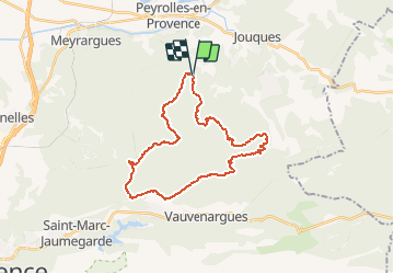
Trail Running of 30 km to be discovered at Provence-Alpes-Côte d'Azur, Bouches-du-Rhône, Peyrolles-en-Provence. This trail is proposed by prof_physique.
Positioning
Country:
France
Region :
Provence-Alpes-Côte d'Azur
Department/Province :
Bouches-du-Rhône
Municipality :
Peyrolles-en-Provence
Location:
Unknown
Start:(Dec)
Start:(UTM)
709458 ; 4832837 (31T) N.
Comments