


mostuejouls

colber
User
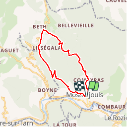

Length
13.3 km

Max alt
868 m

Uphill gradient
543 m
Km-Effort
21 km

Min alt
433 m

Downhill gradient
542 m
Boucle
Yes
Creation date :
2014-12-10 00:00:00.0
Updated on :
2014-12-10 00:00:00.0
3h52
Difficulty : Unknown

FREE GPS app for hiking
 SityTrail
IGN / Geographical institutes
SityTrail Plus
The world is yours!
About
Trail Walking of 13.3 km to be discovered at Occitania, Aveyron, Mostuéjouls. This trail is proposed by colber.
Description
Moyen dur
Positioning
Country:
France
Region :
Occitania
Department/Province :
Aveyron
Municipality :
Mostuéjouls
Location:
Unknown
Start:(Dec)
Start:(UTM)
514878 ; 4894258 (31T) N.
Comments