


O2bikers_27_Ronqueres

O2 bikers
Randonnées de O2bikers GUIDE+
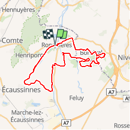

Length
29 km

Max alt
133 m

Uphill gradient
397 m
Km-Effort
35 km

Min alt
53 m

Downhill gradient
398 m
Boucle
Yes
Creation date :
2014-12-11 00:00:00.0
Updated on :
2014-12-11 00:00:00.0
4h33
Difficulty : Unknown

FREE GPS app for hiking
 SityTrail
IGN / Geographical institutes
SityTrail Plus
The world is yours!
About
Trail Mountain bike of 29 km to be discovered at Wallonia, Hainaut, Braine-le-Comte. This trail is proposed by O2 bikers.
Positioning
Country:
Belgium
Region :
Wallonia
Department/Province :
Hainaut
Municipality :
Braine-le-Comte
Location:
Ronquières
Start:(Dec)
Start:(UTM)
586446 ; 5606890 (31U) N.
Comments
didier ??????
Didier ??????
Beaucoup de route pour un o2 Bikers