Trail Walking Gray - La forêt des Hauts Bois - Gray - Photo

La forêt des Hauts Bois - Gray

 tracegps
tracegps

User

© OpenStreetMap contributors
Length
Length
23 km
Max alt
Max alt
260 m
Uphill gradient
Uphill gradient
351 m
Km-Effort
Km-Effort  
28 km
Min alt
Min alt
192 m
Downhill gradient
Downhill gradient
354 m
Boucle
Boucle
Yes
Creation date :
2014-12-10 00:00:00.0
Updated on :
2014-12-10 00:00:00.0

(0 Reviews)

Walking
Walking
6h00
Difficulty : Very difficult

Scan this QR Code to open this trail in the SityTrail application

FREE GPS app for hiking

Logo SityTrail SityTrail

IGN / Geographical institutes

Download SityTrail from the App Store Download SityTrail from Google Play

Logo SityTrail SityTrail World

The world is yours!

Download SityTrail from the App Store Download SityTrail from Google Play Download SityTrail on Huawei AppGallery

About

Trail Walking of 23 km to be discovered at Bourgogne-Franche-Comté, Haute-Saône, Gray. This trail is proposed by tracegps.

Description

Circuit au départ de l'avenue de la libération. Le parcours emprunte, en grande partie, la forêt domaniale des Hauts Bois.

Elevation profile

Photos

Positioning

Country:
France
Region :
Bourgogne-Franche-Comté
Department/Province :
Haute-Saône
Municipality :
Gray
Location:
Unknown
Start:(UTM)
695225 ; 5257433 (31T) N.

Trails nearby

Trail Road bike Gray - bords de Saône  - Photo
Road bike
bernadette revoux

Road bike

Very easy
Gray, Bourgogne-Franche-Comté, Haute-Saône, France
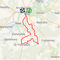
19.3 km | 21 km-effort
1h 13min
No
Trail Walking Chargey-lès-Gray - rallye chargey - Photo
Walking
christianpagani

Walking

Easy
Chargey-lès-Gray, Bourgogne-Franche-Comté, Haute-Saône, France
196 km | 227 km-effort
525h 11min
No
Trail Motor Gray - jura historic étape2 - Photo
Motor
i20

Motor

Very easy
Gray, Bourgogne-Franche-Comté, Haute-Saône, France
125 km | 141 km-effort
4h 50min
No
Trail Motor Gray - Jura historique étape 2 - Photo
Motor
i20

Motor

Difficult
Gray, Bourgogne-Franche-Comté, Haute-Saône, France
126 km | 142 km-effort
4h 27min
No
Trail Walking Gray - Gray. Fontaine française - Photo
Walking
loupblanc.68

Walking

Medium
Gray, Bourgogne-Franche-Comté, Haute-Saône, France
31 km | 36 km-effort
10h 2min
No
Trail Walking Chargey-lès-Gray - 2012-03-04 - 15h53m42 - Photo
Walking
christianpagani

Walking

Very easy
Chargey-lès-Gray, Bourgogne-Franche-Comté, Haute-Saône, France
3.1 km | 3.3 km-effort
57min
Yes
Trail Walking Gray - gray 2 - Photo
Walking
Robert Donnet

Walking

Easy
Gray, Bourgogne-Franche-Comté, Haute-Saône, France
1.9 km | 2.2 km-effort
2h 27min
Yes
Trail Walking Gray - gray - Photo
Walking
Robert Donnet

Walking

Easy
Gray, Bourgogne-Franche-Comté, Haute-Saône, France
423 m | 479 m-effort
1h 28min
Yes
Trail Walking Gray - rien - Photo
Walking
Robert Donnet

Walking

Very easy
Gray, Bourgogne-Franche-Comté, Haute-Saône, France
12 m | 0 m-effort
2min
No


Close
My subscriptions