


O2bikers_45_Sart_tilman

O2 bikers
Randonnées de O2bikers GUIDE+
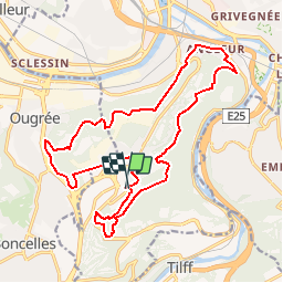

Length
18.6 km

Max alt
255 m

Uphill gradient
416 m
Km-Effort
24 km

Min alt
63 m

Downhill gradient
419 m
Boucle
Yes
Creation date :
2014-12-11 00:00:00.0
Updated on :
2014-12-11 00:00:00.0
3h10
Difficulty : Unknown

FREE GPS app for hiking
 SityTrail
IGN / Geographical institutes
SityTrail Plus
The world is yours!
About
Trail Mountain bike of 18.6 km to be discovered at Wallonia, Liège, Liège. This trail is proposed by O2 bikers.
Positioning
Country:
Belgium
Region :
Wallonia
Department/Province :
Liège
Municipality :
Liège
Location:
Angleur
Start:(Dec)
Start:(UTM)
681756 ; 5606851 (31U) N.
Comments
la partie Boncelles - Ougrée est en partie impraticable par arbres couchée, ronce, nouvelles route bétonnée, dénivelé trop abrupte
nickel