Trail Walking Neufchâtel-en-Bray - Autour de Neufchâtel en Bray - Photo

Autour de Neufchâtel en Bray

 tracegps
tracegps

User

© OpenStreetMap contributors
Length
Length
13.9 km
Max alt
Max alt
225 m
Uphill gradient
Uphill gradient
234 m
Km-Effort
Km-Effort  
17 km
Min alt
Min alt
75 m
Downhill gradient
Downhill gradient
235 m
Boucle
Boucle
Yes
Creation date :
2014-12-10 00:00:00.0
Updated on :
2014-12-10 00:00:00.0

(0 Reviews)

Walking
Walking
3h30
Difficulty : Difficult

Scan this QR Code to open this trail in the SityTrail application

FREE GPS app for hiking

Logo SityTrail SityTrail

IGN / Geographical institutes

Download SityTrail from the App Store Download SityTrail from Google Play

Logo SityTrail SityTrail World

The world is yours!

Download SityTrail from the App Store Download SityTrail from Google Play Download SityTrail on Huawei AppGallery

About

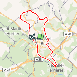
Trail Walking of 13.9 km to be discovered at Normandy, Seine-Maritime, Neufchâtel-en-Bray. This trail is proposed by tracegps.

Description

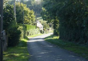
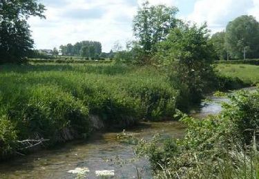
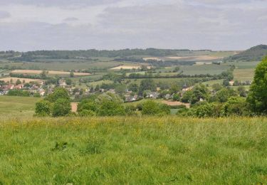
Circuit proposé par l'Office de Tourisme du Pays de Neufchâtelois. De votre point de départ, très rapidement, vous laisserez l'Avenue Verte pour vous élever au-dessus de Neufchâtel. Sur cette première partie de parcours, vous ne manquerez pas d'admirer la vallée de la Béthune qui file vers Dieppe ou encore quelques vues sur le bourg Neufchâtelois. L'itinéraire vous emmènera au sud de Neufchâtel, sur la commune de Neuville-Ferrières où vous rejoindrez l’Avenue Verte au PN73. L'Avenue Verte vous ramènera à votre point de départ : l'ancienne gare de Neufchâtel.

Elevation profile

Photos

Positioning

Country:
France
Region :
Normandy
Department/Province :
Seine-Maritime
Municipality :
Neufchâtel-en-Bray
Location:
Unknown
Start:(UTM)
387282 ; 5510158 (31U) N.

Trails nearby

Trail Walking Bully - Autour de Bully - Photo
Walking
tracegps

Walking

Easy
(1)
Bully, Normandy, Seine-Maritime, France
5.7 km | 7.9 km-effort
1h 30min
Yes
Trail Walking Mesnières-en-Bray - Mesniere en Bray  - Photo
Walking
crocheval

Walking

Easy
(2)
Mesnières-en-Bray, Normandy, Seine-Maritime, France
13.6 km | 17.5 km-effort
4h 5min
Yes
Trail Walking Saint-Saire - St-Saire - Forges-les-Eaux - GD - Photo
Walking
philippe76

Walking

Difficult
(1)
Saint-Saire, Normandy, Seine-Maritime, France
11.5 km | 13 km-effort
3h 9min
No
Trail Walking Mesnières-en-Bray - Autour de Mesnières en Bray  - Photo
Walking
tracegps

Walking

Medium
Mesnières-en-Bray, Normandy, Seine-Maritime, France
17.6 km | 22 km-effort
3h 19min
Yes
Trail Cycle Saint-Saire - Le petit tour vélo du Neufchâtelois - Saint-Saire - Photo
Cycle
tracegps

Cycle

Medium
Saint-Saire, Normandy, Seine-Maritime, France
61 km | 73 km-effort
5h 0min
Yes
Trail Cycle Saint-Saire - Le Grand Tour vélo du Neufchâtelois - Saint-Saire - Photo
Cycle
tracegps

Cycle

Difficult
Saint-Saire, Normandy, Seine-Maritime, France
78 km | 94 km-effort
6h 30min
Yes
Trail Cycle Neuville-Ferrières - La Bonde - Neuville Ferrières - Photo
Cycle
tracegps

Cycle

Medium
Neuville-Ferrières, Normandy, Seine-Maritime, France
29 km | 35 km-effort
2h 30min
Yes
Trail Cycle Saint-Saire - La boucle des Calvaires - Saint-Saire - Photo
Cycle
tracegps

Cycle

Easy
Saint-Saire, Normandy, Seine-Maritime, France
15 km | 17.9 km-effort
1h 15min
Yes
Trail Cycle Nesle-Hodeng - Le coeur - Nesle Hodeng - Photo
Cycle
tracegps

Cycle

Medium
Nesle-Hodeng, Normandy, Seine-Maritime, France
33 km | 39 km-effort
3h 0min
Yes


Close
My subscriptions