


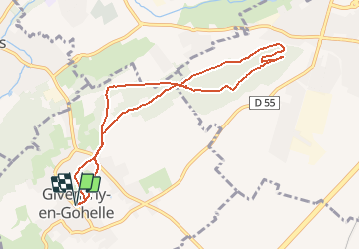
Givenchy en Gohelle et le terril des Pinchonvalles

tracegps
User

Length
8.3 km

Max alt
117 m

Uphill gradient
148 m
Km-Effort
10.3 km

Min alt
47 m

Downhill gradient
148 m
Boucle
Yes
Creation date :
2014-12-10 00:00:00.0
Updated on :
2014-12-10 00:00:00.0
2h00
Difficulty : Medium

FREE GPS app for hiking
 SityTrail
IGN / Geographical institutes
SityTrail Plus
The world is yours!
About
Trail Walking of 8.3 km to be discovered at Hauts-de-France, Pas-de-Calais, Givenchy-en-Gohelle. This trail is proposed by tracegps.
Description
Très belle promenade au départ de Givenchy en Gohelle sur le terril des Pinchonvalles avec de magnifiques vues sur l'ancien bassin minier.
Photos

Positioning
Country:
France
Region :
Hauts-de-France
Department/Province :
Pas-de-Calais
Municipality :
Givenchy-en-Gohelle
Location:
Unknown
Start:(Dec)
Start:(UTM)
483825 ; 5582156 (31U) N.
Comments