Trail Walking Courson-Monteloup - Autour de Breuillet - Courson Monteloup - Photo

Autour de Breuillet - Courson Monteloup

 tracegps
tracegps

User

© OpenStreetMap contributors
Length
Length
27 km
Max alt
Max alt
157 m
Uphill gradient
Uphill gradient
407 m
Km-Effort
Km-Effort  
32 km
Min alt
Min alt
47 m
Downhill gradient
Downhill gradient
401 m
Boucle
Boucle
Yes
Creation date :
2014-12-10 00:00:00.0
Updated on :
2014-12-10 00:00:00.0

(0 Reviews)

Walking
Walking
6h00
Difficulty : Difficult

Scan this QR Code to open this trail in the SityTrail application

FREE GPS app for hiking

Logo SityTrail SityTrail

IGN / Geographical institutes

Download SityTrail from the App Store Download SityTrail from Google Play

Logo SityTrail SityTrail World

The world is yours!

Download SityTrail from the App Store Download SityTrail from Google Play Download SityTrail on Huawei AppGallery

About

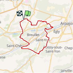
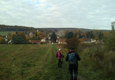
Trail Walking of 27 km to be discovered at Ile-de-France, Essonne, Courson-Monteloup. This trail is proposed by tracegps.

Description

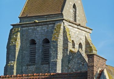
Au départ de Courson Monteloup, ce circuit rejoint d’abord Bruyères le Châtel via la Charmoise. Il contourne ensuite l’étang de Trêvoix pour passer en rive sud de l’Orge. Après le bois de Baville, voici Saint Sulpice de Favières avec son imposante église du 13eme siècle. Le GR1 nous conduit ensuite à proximité de Saint Chéron ; enfin le GR111D nous ramène en rive nord de l’Orge puis de la Rémarde, jusqu’aux environs de Courson.

Elevation profile

Photos

Positioning

Country:
France
Region :
Ile-de-France
Department/Province :
Essonne
Municipality :
Courson-Monteloup
Location:
Unknown
Start:(UTM)
436768 ; 5382830 (31U) N.

Trails nearby

Trail On foot Saint-Yon - Sur les traces de la Renarde - Photo
On foot
PRO

On foot

Very difficult
Saint-Yon, Ile-de-France, Essonne, France
38 km | 44 km-effort
10h 4min
No
Trail Mountain bike Fontenay-lès-Briis - Soucy / Le Marais - Photo
Mountain bike
Bora431

Mountain bike

Medium
(2)
Fontenay-lès-Briis, Ile-de-France, Essonne, France
25 km | 30 km-effort
1h 52min
Yes
Trail Walking Bruyères-le-Châtel - Boucle Fontenay les Briis - Photo
Walking
chessyca

Walking

Very easy
Bruyères-le-Châtel, Ile-de-France, Essonne, France
22 km | 26 km-effort
5h 4min
Yes
Trail Walking Saint-Maurice-Montcouronne - Boucle St Maurice Montcouronne - Brigitte - Photo
Walking
chessyca

Walking

Very easy
Saint-Maurice-Montcouronne, Ile-de-France, Essonne, France
21 km | 24 km-effort
4h 19min
Yes
Trail Walking Fontenay-lès-Briis - Essonne_Fontenay-Les-Briis=>Roche-Turpin=>Soucy(bis) - Photo
Walking
BMorin91470

Walking

Easy
Fontenay-lès-Briis, Ile-de-France, Essonne, France
8.6 km | 10.2 km-effort
2h 8min
Yes
Trail On foot Saint-Yon - FR-1 - Photo
On foot
PRO

On foot

Easy
Saint-Yon, Ile-de-France, Essonne, France
7.7 km | 8.4 km-effort
1h 54min
No
Trail Walking Bruyères-le-Châtel - Essonne_Fontenay-Les-Briis=>LaRocheTurpin - Photo
Walking
BMorin91470

Walking

Very easy
Bruyères-le-Châtel, Ile-de-France, Essonne, France
5.5 km | 6.8 km-effort
1h 23min
Yes
Trail Nordic walking Breuillet - Breuillet St Sulpice - Photo
Nordic walking
Zygomat

Nordic walking

Easy
(1)
Breuillet, Ile-de-France, Essonne, France
10.6 km | 13 km-effort
2h 20min
Yes
Trail Walking Boissy-sous-Saint-Yon - Boissy sous St Yon - Photo
Walking
c.chehere

Walking

Easy
Boissy-sous-Saint-Yon, Ile-de-France, Essonne, France
16.6 km | 20 km-effort
4h 43min
Yes


Close
My subscriptions