


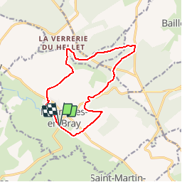
Circuit de la forêt du Hellet - Mesnières en Bray

tracegps
User


3h00
Difficulty : Medium

FREE GPS app for hiking
 SityTrail
IGN / Geographical institutes
SityTrail Plus
The world is yours!
About
Trail Walking of 11.9 km to be discovered at Normandy, Seine-Maritime, Mesnières-en-Bray. This trail is proposed by tracegps.
Description
Circuit proposé par l'Office de Tourisme du Pays de Neufchâtelois. Départ du passage à niveau n° 82 de l'avenue verte à Mesnières-en-Bray. Sur la colline Saint-Amador, le sentier pédagogique et la table d'orientation vous permettront d'apprécier le panorama et la diversité de la flore environnante.
Photos


Positioning
Comments