


O2bikers_72_Gulpen

O2 bikers
Randonnées de O2bikers GUIDE+
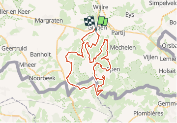

Length
36 km

Max alt
251 m

Uphill gradient
797 m
Km-Effort
47 km

Min alt
96 m

Downhill gradient
800 m
Boucle
Yes
Creation date :
2014-12-11 00:00:00.0
Updated on :
2014-12-11 00:00:00.0
--
Difficulty : Unknown

FREE GPS app for hiking
 SityTrail
IGN / Geographical institutes
SityTrail Plus
The world is yours!
About
Trail Other activity of 36 km to be discovered at Limburg, Unknown, Gulpen-Wittem. This trail is proposed by O2 bikers.
Positioning
Country:
Netherlands
Region :
Limburg
Department/Province :
Unknown
Municipality :
Gulpen-Wittem
Location:
Unknown
Start:(Dec)
Start:(UTM)
703481 ; 5632594 (31U) N.
Comments