Trail Walking Saint-Christophe-de-Chaulieu - La Forêt (n° 13)  - Saint Christophe de Chaulieu - Photo

La Forêt (n° 13) - Saint Christophe de Chaulieu

 tracegps
tracegps

User

© OpenStreetMap contributors
Length
Length
6.5 km
Max alt
Max alt
325 m
Uphill gradient
Uphill gradient
141 m
Km-Effort
Km-Effort  
8.4 km
Min alt
Min alt
250 m
Downhill gradient
Downhill gradient
141 m
Boucle
Boucle
Yes
Creation date :
2014-12-10 00:00:00.0
Updated on :
2014-12-10 00:00:00.0

(0 Reviews)

Walking
Walking
1h40
Difficulty : Easy

Scan this QR Code to open this trail in the SityTrail application

FREE GPS app for hiking

Logo SityTrail SityTrail

IGN / Geographical institutes

Download SityTrail from the App Store Download SityTrail from Google Play

Logo SityTrail SityTrail World

The world is yours!

Download SityTrail from the App Store Download SityTrail from Google Play Download SityTrail on Huawei AppGallery

About

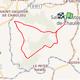
Trail Walking of 6.5 km to be discovered at Normandy, Orne, Saint-Christophe-de-Chaulieu. This trail is proposed by tracegps.

Description

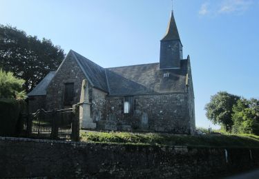
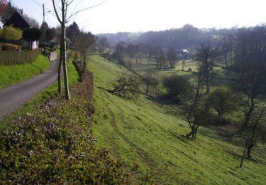
La Communauté de communes, en partenariat avec le Comité Départemental du Tourisme a mis en place un réseau d'itinéraires de randonnée et de découverte du bocage du pays de Tinchebray. Départ de l'église de Saint-Christophe-de-Chaulieu. Propriété privé, le bois de St-Christophe représente 124 ha, soit 1/5e de la superficie de la commune. Cet écrin de verdure parcouru par d’agréables routes forestières et un paysage valloné (La butte Brimbal, culmine à 367 m d'altitude) offre un cadre très agréable pour la randonnée sous toutes ses formes. Retrouvez le plan et le descriptif sur le site de la Communauté de communes du Pays de Thinchebray

Elevation profile

Photos

Positioning

Country:
France
Region :
Normandy
Department/Province :
Orne
Municipality :
Saint-Christophe-de-Chaulieu
Location:
Unknown
Start:(UTM)
660171 ; 5401521 (30U) N.

Trails nearby

Trail On foot Saint-Christophe-de-Chaulieu - La Forêt - Photo
On foot
PRO

On foot

Easy
Saint-Christophe-de-Chaulieu, Normandy, Orne, France
6 km | 7.6 km-effort
1h 43min
No
Trail Mountain bike Saint-Christophe-de-Chaulieu - La Forêt (n° 13)  - Saint Christophe de Chaulieu - Photo
Mountain bike
tracegps

Mountain bike

Easy
Saint-Christophe-de-Chaulieu, Normandy, Orne, France
6.5 km | 8.4 km-effort
34min
Yes
Trail Mountain bike Saint-Quentin-les-Chardonnets - Jardins extraordinaires (N°15) - Saint-Quentin-des-Chardonnets - Photo
Mountain bike
tracegps

Mountain bike

Easy
Saint-Quentin-les-Chardonnets, Normandy, Orne, France
7.1 km | 8.5 km-effort
45min
Yes
Trail Walking Saint-Quentin-les-Chardonnets - Jardins extraordinaires (N°15) - Saint-Quentin-des-Chardonnets - Photo
Walking
tracegps

Walking

Easy
Saint-Quentin-les-Chardonnets, Normandy, Orne, France
7.1 km | 8.5 km-effort
1h 45min
Yes
Trail Walking Tinchebray-Bocage - Michelot Moulin - Pays de Tinchebray - Photo
Walking
tracegps

Walking

Medium
Tinchebray-Bocage, Normandy, Orne, France
12.4 km | 15.4 km-effort
3h 0min
Yes
Trail On foot Vire Normandie - Le Marais de Truttemer - Photo
On foot
PRO

On foot

Easy
Vire Normandie, Normandy, Calvados, France
5.7 km | 6.4 km-effort
1h 26min
Yes
Trail On foot Saint-Quentin-les-Chardonnets - Jardins extraordinaires - Photo
On foot
PRO

On foot

Easy
Saint-Quentin-les-Chardonnets, Normandy, Orne, France
3.1 km | 3.7 km-effort
50min
No
Trail Walking Tinchebray-Bocage - Saint Jean des Bois Flers 12.4 Km - Photo
Walking
ODDAD78

Walking

Easy
Tinchebray-Bocage, Normandy, Orne, France
12.4 km | 15.4 km-effort
3h 19min
Yes
Trail Motor Le Fresne-Poret - 2012-05-19 12h30m52 - Photo
Motor
davdaso

Motor

Easy
Le Fresne-Poret, Normandy, Manche, France
47 km | 57 km-effort
2h 48min
Yes


Close
My subscriptions